| Navigation | |
| Donate | |
|
HELP KEEP OUR SERVERS ONLINE!
|
 |
Current Donation Stats |
| May's Goal: |
$360.00 |
| Due Date: |
May 31 |
| Amount in: |
$0.00 |
| Balance: |
$0.00 |
| Left to go: |
$360.00 |
| | | | |
|
fsx downloads, fsx aircraft, FS2004 aircrafts, fsx plane, Prepar3d, x-plane, fsx addons WELCOME
lbninjaas a Simnetwork new user
Registered Members: 16945 Super Administrators: 2
Moderators: 1 Users: 16938
Members Online:
Guests Online: 1
| Forum Categories | 39 |
| Forum Threads | 700 |
| Forum Posts | 1313 |
| Comments | 84 |
| News | 225 |
| Articles | 45 |
| Downloaded files | 16542 |
| Web Links | 43 |
| Total Downloaded Files | |
1686790 | | | | |
|
| Google Ads | |
| Downloads: Fsx Scenery downloads | |
|
| FSX Scenery--Oshkosh Air Show |
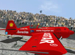 FSX Scenery--Oshkosh Air Show for FSX Acceleration only. This scenery will add crowds, seats and aircraft to the airport KOSH in Wisconsin (WI), to make it look like an airshow. By Daniel Kemmer. 1.2 mb FSX Scenery--Oshkosh Air Show for FSX Acceleration only. This scenery will add crowds, seats and aircraft to the airport KOSH in Wisconsin (WI), to make it look like an airshow. By Daniel Kemmer. 1.2 mb |
| Author: |
O/S: all |
Version: FSX |
| Added: 02.08.08 |
Downloads: 124 |
 (1.2 mb) (1.2 mb) |
| FSX Scenery--McEntire Joint National Guard Base |
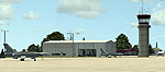 FSX Scenery--McEntire Joint National Guard Base (KMNT), Eastover, South Carolina (SC). An improved version with added parking, fire station with trucks, replaced buildings, added fuel strucks, adjust taxiways and more. By Jim Cook. 18 kb FSX Scenery--McEntire Joint National Guard Base (KMNT), Eastover, South Carolina (SC). An improved version with added parking, fire station with trucks, replaced buildings, added fuel strucks, adjust taxiways and more. By Jim Cook. 18 kb |
| Author: |
O/S: all |
Version: FSX |
| Added: 02.08.08 |
Downloads: 87 |
(18 kb) |

| Kiwi360 (KiwiFruit Country)- Custom buildings, helipad, Hi Res |
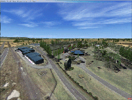 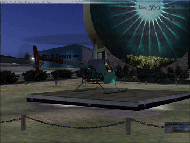 Kiwi360 (formally know as Kiwifruit Country) is a theme park based around the Kiwifruit (AK.A Chinese Gooseberry or Zespri- The trade name) which is a major export of New Zealand grown predominately in the Bay of Plenty Region. The park is situated about midway between Tauranga and Whakatane, about 5km east of the township of Te Puke. The Bay of Plenty’s sunny climate ensures good growing conditions for the delicious fruit and has also spawned a mini tourist industry of tours of the orchards and sorting/packing/coolstores. These include tourist flights by Aerius (https://www.aerius.co.nz ) using a Robinson R44 helicopter. • This scenery was made after a visit when carrying out a GPS survey: I took a few photos and whacked it up. It isn’t perfect but will be useful for flights in small helos (I.e. Robinson R22, R44 or Hughes 300/269). • It includes the famous giant Kiwifruit slice, the helipad next to it; the main Kiwi 360 building; a large coolstore/packhouse and the backpackers next to the park. It also includes a lot of library objects (especially trees- If these are adversely affecting performance, you can disable this bgl) • This is placed on a high resolution aerial photo provided by Environment Bay of Plenty. • The scenery also has reflection maps and night maps for those who like getting up at the crack of dawn or simulating frost protection work (although I don’t believe the pad is certified for night operations in real life). • The download also includes a repaint of the default Robinson R22 in the colours of ZK-HJZ (in actual fact an R44) kindly provided by James Eden from the ARNZ Forums (see the readme for the .cfg entry to add this repaint) This helipad isn’t in controlled airspace but Tauranga Tower is nearby and will need to be called before entering their airspace (above 2500ft LL for the CTA or within about 10nm of Tauranga for the CTZ) Radio procedures are carried out on ‘Christchurch Information’ 125.5 for flight following/planning. Tim Barnes, James Eden 12 mb Kiwi360 (formally know as Kiwifruit Country) is a theme park based around the Kiwifruit (AK.A Chinese Gooseberry or Zespri- The trade name) which is a major export of New Zealand grown predominately in the Bay of Plenty Region. The park is situated about midway between Tauranga and Whakatane, about 5km east of the township of Te Puke. The Bay of Plenty’s sunny climate ensures good growing conditions for the delicious fruit and has also spawned a mini tourist industry of tours of the orchards and sorting/packing/coolstores. These include tourist flights by Aerius (https://www.aerius.co.nz ) using a Robinson R44 helicopter. • This scenery was made after a visit when carrying out a GPS survey: I took a few photos and whacked it up. It isn’t perfect but will be useful for flights in small helos (I.e. Robinson R22, R44 or Hughes 300/269). • It includes the famous giant Kiwifruit slice, the helipad next to it; the main Kiwi 360 building; a large coolstore/packhouse and the backpackers next to the park. It also includes a lot of library objects (especially trees- If these are adversely affecting performance, you can disable this bgl) • This is placed on a high resolution aerial photo provided by Environment Bay of Plenty. • The scenery also has reflection maps and night maps for those who like getting up at the crack of dawn or simulating frost protection work (although I don’t believe the pad is certified for night operations in real life). • The download also includes a repaint of the default Robinson R22 in the colours of ZK-HJZ (in actual fact an R44) kindly provided by James Eden from the ARNZ Forums (see the readme for the .cfg entry to add this repaint) This helipad isn’t in controlled airspace but Tauranga Tower is nearby and will need to be called before entering their airspace (above 2500ft LL for the CTA or within about 10nm of Tauranga for the CTZ) Radio procedures are carried out on ‘Christchurch Information’ 125.5 for flight following/planning. Tim Barnes, James Eden 12 mb |
| Author: |
O/S: all |
Version: FSX |
| Added: 02.08.08 |
Downloads: 73 |
(12 mb) |
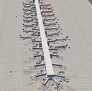
| Detroit Metropolitan Wayne County Airport V2 |
  This is my second version of Detroit Metropolitan Wayne County Airport in Detroit MI. This version was created with Airport Design Editor, which was designed exclusively for use with FSX. The following improvements have been made: 1. All commercial and cargo aircraft will park at their assigned spots. All gates for all airlines are included. All Northwest Airlines and Northwest Airlink aircraft will park at the two McNamara terminals. The west side of the McNamara Terminal has been expanded using buildings designed with Abacus' FS Design Studio to provide more parking for Northwest Airlink and includes all of the gates as listed on the airport's diagram at its web site, along with several new jetways. The jetways for Northwest Airlink aircraft have been scaled down to line up with the smaller aircraft better. 2. The vehicle paths have been redesigned, which should eliminate the problem of airport vehicles using taxiways, which can cause taxiing airplanes to come to a standstill and cause traffic to back up. 3. When in tower view, the view will be from the roof of the control tower, thanks to Airport Design Editor. 4. An assigned cargo area has been added for UPS and FedEx aircraft, and some scenery objects added with ADE. 5. Crosswind runways have been activated, which will open all six runways to airline traffic. This is an optional feature, and will be explained in the INSTALL.doc file. 6. Several fuel trucks have been added, and should serve departing aircraft quickly. 7. Settings have been changed in ADE so that all jetways will display as long as Scenery Density in FSX is set at Normal or higher. Please be aware that this scenery is for use with FSX only. It will not work with FS9. Patrick Finch 616 kb This is my second version of Detroit Metropolitan Wayne County Airport in Detroit MI. This version was created with Airport Design Editor, which was designed exclusively for use with FSX. The following improvements have been made: 1. All commercial and cargo aircraft will park at their assigned spots. All gates for all airlines are included. All Northwest Airlines and Northwest Airlink aircraft will park at the two McNamara terminals. The west side of the McNamara Terminal has been expanded using buildings designed with Abacus' FS Design Studio to provide more parking for Northwest Airlink and includes all of the gates as listed on the airport's diagram at its web site, along with several new jetways. The jetways for Northwest Airlink aircraft have been scaled down to line up with the smaller aircraft better. 2. The vehicle paths have been redesigned, which should eliminate the problem of airport vehicles using taxiways, which can cause taxiing airplanes to come to a standstill and cause traffic to back up. 3. When in tower view, the view will be from the roof of the control tower, thanks to Airport Design Editor. 4. An assigned cargo area has been added for UPS and FedEx aircraft, and some scenery objects added with ADE. 5. Crosswind runways have been activated, which will open all six runways to airline traffic. This is an optional feature, and will be explained in the INSTALL.doc file. 6. Several fuel trucks have been added, and should serve departing aircraft quickly. 7. Settings have been changed in ADE so that all jetways will display as long as Scenery Density in FSX is set at Normal or higher. Please be aware that this scenery is for use with FSX only. It will not work with FS9. Patrick Finch 616 kb |
| Author: |
O/S: all |
Version: FSX |
| Added: 02.08.08 |
Downloads: 213 |
(616 kb) |
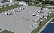
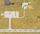
| Napa County Airport (KAPC) |
 This is a scenery update for Napa County airport in Northern California. Taxiways, runways, and parking were all updated using real satellite images from Google Earth for almost complete accuracy. Some objects from the default FSX scenery libraries were updated. View Readme file for installation and notes. Compiled using Airport Design Editor. By Phillip Coyle. Phillip Coyle 297 kb This is a scenery update for Napa County airport in Northern California. Taxiways, runways, and parking were all updated using real satellite images from Google Earth for almost complete accuracy. Some objects from the default FSX scenery libraries were updated. View Readme file for installation and notes. Compiled using Airport Design Editor. By Phillip Coyle. Phillip Coyle 297 kb |
| Author: |
O/S: all |
Version: FSX |
| Added: 02.08.08 |
Downloads: 80 |
(297 kb) |
| Arcata Airport (KACV) |
 This is the next addition to my Northern California airport series. This updates Arcata airport in Arcata/Eureka. Taxiways, runways, and parking were updated using real world coordinates through Google Earth. The default FSX runway 2-20 was changed to the correct real-life runway 1-19. A few objects from the default FSX scenery libraries were also added. View Readme file for installation and notes. Compiled using Airport Design Editor. By Phillip Coyle 324 kb This is the next addition to my Northern California airport series. This updates Arcata airport in Arcata/Eureka. Taxiways, runways, and parking were updated using real world coordinates through Google Earth. The default FSX runway 2-20 was changed to the correct real-life runway 1-19. A few objects from the default FSX scenery libraries were also added. View Readme file for installation and notes. Compiled using Airport Design Editor. By Phillip Coyle 324 kb |
| Author: |
O/S: all |
Version: FSX |
| Added: 23.07.08 |
Downloads: 22 |
(324 kb) |
| FSX Scenery--St. Helen 5m Mesh |
 FSX Scenery--St. Helen 5m Mesh. A mesh file for the area of the St. Helen volcano designed using high resolution elevation model compiled on a 4.8 m. By Raimondo Taburet. 1.7 mb FSX Scenery--St. Helen 5m Mesh. A mesh file for the area of the St. Helen volcano designed using high resolution elevation model compiled on a 4.8 m. By Raimondo Taburet. 1.7 mb |
| Author: |
O/S: all |
Version: FSX |
| Added: 23.07.08 |
Downloads: 118 |
(1.7 mb) |
| Garberville Airport (O16) |
 This scenery package updates the small Garberville airport, located on the Northern California Coast. Taxiway widths, runways, and parking were updated. This also places a few objects from the default FSX scenery libraries. View Readme file for installation and notes. Compiled using Airport Design Editor. By Phillip Coyle.296 kb This scenery package updates the small Garberville airport, located on the Northern California Coast. Taxiway widths, runways, and parking were updated. This also places a few objects from the default FSX scenery libraries. View Readme file for installation and notes. Compiled using Airport Design Editor. By Phillip Coyle.296 kb |
| Author: |
O/S: all |
Version: FSX |
| Added: 23.07.08 |
Downloads: 26 |
(296 kb) |
| Arcata Airport (KACV) |
| This is the next addition to my Northern California airport series. This updates Arcata airport in Arcata/Eureka. Taxiways, runways, and parking were updated using real world coordinates through Google Earth. The default FSX runway 2-20 was changed to the correct real-life runway 1-19. A few objects from the default FSX scenery libraries were also added. View Readme file for installation and notes. Compiled using Airport Design Editor. By Phillip Coyle 324 kb |
| Author: |
O/S: all |
Version: FSX |
| Added: 23.07.08 |
Downloads: 18 |
(324 kb) |
| FSX UK Scenery--QE2 |
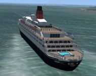 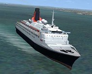 FSX UK Scenery--QE2. The Queen Elizabeth 2 was the flagship of the Cunard Line for over 30 years. QE2 made her maiden voyage in 1969 and is one of the last great Transatlantic liners as well as one of the largest and fastest passenger vessels afloat. This model is presented in a static (docked at Southampton UK) version and moving (from Southampton to Naples) version. Generation X VFR Photographic Scenery Vol. 1 recommended. By Simon Swallow. 1.8 MB FSX UK Scenery--QE2. The Queen Elizabeth 2 was the flagship of the Cunard Line for over 30 years. QE2 made her maiden voyage in 1969 and is one of the last great Transatlantic liners as well as one of the largest and fastest passenger vessels afloat. This model is presented in a static (docked at Southampton UK) version and moving (from Southampton to Naples) version. Generation X VFR Photographic Scenery Vol. 1 recommended. By Simon Swallow. 1.8 MB |
| Author: |
O/S: all |
Version: FSX |
| Added: 23.07.08 |
Downloads: 110 |
(1.8 MB) |
| Runway 12 scenery objects |
  38 mixed airport buildings and objects. For placement using the Runway 12 object placer. Tony Adams 1.3 mb 38 mixed airport buildings and objects. For placement using the Runway 12 object placer. Tony Adams 1.3 mb |
| Author: |
O/S: all |
Version: FSX |
| Added: 23.07.08 |
Downloads: 54 |
(1.3 mb) |
| FSX Scenery--Seven Castles |
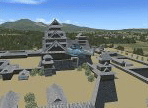 FSX Scenery--Seven Castles (Himeji castle, Kumamoto castle, Osaka castle, Edo castle, E Yatsushiro castle, Hikone Castle, Goryoukaku). They are arranged at the foot of a mountain of Hokkaido, Mt. Youteizann. By Harutoshi Nakagawa. 9.8 mb FSX Scenery--Seven Castles (Himeji castle, Kumamoto castle, Osaka castle, Edo castle, E Yatsushiro castle, Hikone Castle, Goryoukaku). They are arranged at the foot of a mountain of Hokkaido, Mt. Youteizann. By Harutoshi Nakagawa. 9.8 mb |
| Author: |
O/S: all |
Version: FSX |
| Added: 23.07.08 |
Downloads: 26 |
(9.8 mb) |
| SABA ADE Update |
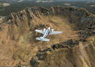
 This is an update of Saba Island airport for FSX made with ADE by Jon Masterson. The airport has been raised to its real world height and moved seawards so that take off from R30 is not aimed straight at the mountain. Parking spaces have been added to enable AI and other default FSX scenery objects have also been added. At 396m the runway is probably the shortest commercial runway in the world and presents a challenge to all pilots to make a precision touchdown. Colin Dietrich 1.3 mb This is an update of Saba Island airport for FSX made with ADE by Jon Masterson. The airport has been raised to its real world height and moved seawards so that take off from R30 is not aimed straight at the mountain. Parking spaces have been added to enable AI and other default FSX scenery objects have also been added. At 396m the runway is probably the shortest commercial runway in the world and presents a challenge to all pilots to make a precision touchdown. Colin Dietrich 1.3 mb |
| Author: Colin Dietrich |
O/S: all |
Version: FSX |
| Added: 23.07.08 |
Downloads: 45 |
(1.3 mb) |
| Sailboat Race |
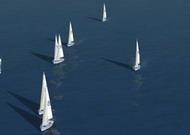 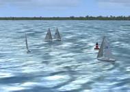 FSX sailboat race in Chester near Halifax, Canada. True race with eight AI-traffic controlled sailboats, each with his own number on sail. Place a bet to the winner! Ralph Eisenegger 1.8 mb FSX sailboat race in Chester near Halifax, Canada. True race with eight AI-traffic controlled sailboats, each with his own number on sail. Place a bet to the winner! Ralph Eisenegger 1.8 mb |
| Author: |
O/S: all |
Version: FSX |
| Added: 23.07.08 |
Downloads: 34 |
(1.8 mb) |
| FSX Scenery--Oradea Airport |
 FSX Scenery--Oradea Airport, Romania (LROD). Based on the stock airport, modified to better match the real airport. Added / modified buildings and added paths between them. Added a few extra scenery elements resembling reality. Extended airport extents and added traces of an old, no longer existing runway. Not present in reality, a small second apron was added to hold very small GA parking spots. In FSX the airport unfortunately appears as reaching into the city of Oradea, which actually is not the case in reality, where the city ends further north. By Ana Gana. 22 kb FSX Scenery--Oradea Airport, Romania (LROD). Based on the stock airport, modified to better match the real airport. Added / modified buildings and added paths between them. Added a few extra scenery elements resembling reality. Extended airport extents and added traces of an old, no longer existing runway. Not present in reality, a small second apron was added to hold very small GA parking spots. In FSX the airport unfortunately appears as reaching into the city of Oradea, which actually is not the case in reality, where the city ends further north. By Ana Gana. 22 kb |
| Author: |
O/S: all |
Version: FSX |
| Added: 10.07.08 |
Downloads: 127 |
(22 kb) |
| | | | |
| Advertisement | |
| *Latest Site Info Panel* | |
|
| Premium Member Login | |
|
Not a Premium member yet? Click here to register.
Forgotten your password? Request a new one here.
| | | | |
| Advertisement | |
| TopSites | |
| Member Poll | |
|