| Navigation | |
| Donate | |
|
HELP KEEP OUR SERVERS ONLINE!
|
 |
Current Donation Stats |
| Jan's Goal: |
$300.00 |
| Due Date: |
Jan 31 |
| Amount in: |
$0.00 |
| Balance: |
$0.00 |
| Left to go: |
$300.00 |
| | | | |
|
fsx downloads, fsx aircraft, FS2004 aircrafts, fsx plane, Prepar3d, x-plane, fsx addons WELCOME
lbninjaas a Simnetwork new user
Registered Members: 16945 Super Administrators: 2
Moderators: 1 Users: 16938
Members Online:
Guests Online: 1
| Forum Categories | 39 |
| Forum Threads | 700 |
| Forum Posts | 1313 |
| Comments | 84 |
| News | 225 |
| Articles | 45 |
| Downloaded files | 16542 |
| Web Links | 43 |
| Total Downloaded Files | |
1686777 | | | | |
|
| Google Ads | |
| Downloads: Fsx Scenery downloads | |
|
| FSX Midway Atoll (Midway Islands) Photoreal Scenery |
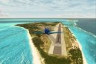 This scenery is dedicated to Bob. Midway Atoll - or Midway Islands as it is often called - is a tiny Atoll at the northwestern end of the Hawaiian Islands chain. It lies halfway between Asia and North America which made it an ideal refueling stop on transpacific flights. Henderson Airfield on Sand Island has a 8,000 ft runway which is ideal for all kinds of heavy metal. Texture resolution is 1m/pixel (LOD 15). Package comes with a simple runway and taxiways and basic airport autogen. By Tiberius Kowalski. 17 mb This scenery is dedicated to Bob. Midway Atoll - or Midway Islands as it is often called - is a tiny Atoll at the northwestern end of the Hawaiian Islands chain. It lies halfway between Asia and North America which made it an ideal refueling stop on transpacific flights. Henderson Airfield on Sand Island has a 8,000 ft runway which is ideal for all kinds of heavy metal. Texture resolution is 1m/pixel (LOD 15). Package comes with a simple runway and taxiways and basic airport autogen. By Tiberius Kowalski. 17 mb |
| Author: |
O/S: all |
Version: FSX |
| Added: 22.11.11 |
Downloads: 17 |
 (17 mb) (17 mb) |

| Bar-le-Duc |
 Bar-le-Duc (France) and its LFEU airfield a few miles south of Verdun. Hi res photoreal ground with seasonal and night variants, bumpy and sloped runway. Detailed hangars (specular, bump materials, smoke effects), animated windsock, static planes, nearest village all in 3D, cars, trucks, and the nearest windfarm of 33 animated and lighted wind turbines. VAC chart included. By D. Bur. 17 mb Bar-le-Duc (France) and its LFEU airfield a few miles south of Verdun. Hi res photoreal ground with seasonal and night variants, bumpy and sloped runway. Detailed hangars (specular, bump materials, smoke effects), animated windsock, static planes, nearest village all in 3D, cars, trucks, and the nearest windfarm of 33 animated and lighted wind turbines. VAC chart included. By D. Bur. 17 mb |
| Author: |
O/S: all |
Version: FSX |
| Added: 20.11.11 |
Downloads: 9 |
(17 mb) |
| Imperial War Museum Duxford, UK, Scenery Package |
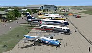 FSX scenery of IWM Duxford, UK. Just about the definitive representation of the Imperial War Museum, Duxford you could wish for. Includes comprehensive photo-realistic buildings and structures on both the north and south sides of the airfield. Fully customisable from a quite day through to an optional air show add-on. Complete with a package of 20 representative AI aircraft. By Stephen Legg and John Young, ACG. 77 mb FSX scenery of IWM Duxford, UK. Just about the definitive representation of the Imperial War Museum, Duxford you could wish for. Includes comprehensive photo-realistic buildings and structures on both the north and south sides of the airfield. Fully customisable from a quite day through to an optional air show add-on. Complete with a package of 20 representative AI aircraft. By Stephen Legg and John Young, ACG. 77 mb |
| Author: |
O/S: all |
Version: FSX |
| Added: 20.11.11 |
Downloads: 73 |
(77 mb) |
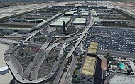
| San Diego International Airport |
 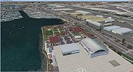 San Diego International Airport, California (CA), USA. This photoreal scenery is a complete rebuild for the default KSAN airport using the latest version of ADE and SBuilderX scenery design tool. SAN is one of the author's favorite airports to fly into because of its beautiful scenery and it also is ranked as #10 on the world's most dangerous airports list. This scenery includes the new expansion of Terminal 2 that is scheduled to be completed in 2013 but the gates and ground textures are not update yet. Includes completely new terminal buildings, new parking garages and buildings on the runway 27 approach, and photo real ground textures that gives the airport a more realistic feeling. Also includes some Google Earth buildings, new warehouse buildings, and several nice scenery enhancements. The runways and airport aprons are aligned to match Google and Yahoo satellite imagery. By Glenn Johnson. 35 mb San Diego International Airport, California (CA), USA. This photoreal scenery is a complete rebuild for the default KSAN airport using the latest version of ADE and SBuilderX scenery design tool. SAN is one of the author's favorite airports to fly into because of its beautiful scenery and it also is ranked as #10 on the world's most dangerous airports list. This scenery includes the new expansion of Terminal 2 that is scheduled to be completed in 2013 but the gates and ground textures are not update yet. Includes completely new terminal buildings, new parking garages and buildings on the runway 27 approach, and photo real ground textures that gives the airport a more realistic feeling. Also includes some Google Earth buildings, new warehouse buildings, and several nice scenery enhancements. The runways and airport aprons are aligned to match Google and Yahoo satellite imagery. By Glenn Johnson. 35 mb |
| Author: |
O/S: all |
Version: FSX |
| Added: 30.10.11 |
Downloads: 57 |
(35 mb) |
| Taupo Extras New Zealand |
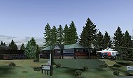 Taupo Extras New Zealand. Includes photoreal Hukafalls / Helistar helibase / Lake Taupo float plane and helipad which is located on the Lake Taupo entrance of the Waikato River right in the heart of Taupo township. Hukafalls is a quick flight up the same river and Helistar is just up from that on the hill which is easy to make out with its trademark Mil Mi17 helicopter and raised helipad, all very handy to the main TaupoX "NZAP" airport from fs-creations.org. By Michael Allen-Andrews. 6 mb Taupo Extras New Zealand. Includes photoreal Hukafalls / Helistar helibase / Lake Taupo float plane and helipad which is located on the Lake Taupo entrance of the Waikato River right in the heart of Taupo township. Hukafalls is a quick flight up the same river and Helistar is just up from that on the hill which is easy to make out with its trademark Mil Mi17 helicopter and raised helipad, all very handy to the main TaupoX "NZAP" airport from fs-creations.org. By Michael Allen-Andrews. 6 mb |
| Author: |
O/S: all |
Version: FSX |
| Added: 30.10.11 |
Downloads: 1 |
(6 mb) |
| Cape Town International |
 Bigger fictional Cape Town International Airport with more gates including the A380 and cargo.Created with ADEX for FSX. Working jetways. Not real-world 1 mb Bigger fictional Cape Town International Airport with more gates including the A380 and cargo.Created with ADEX for FSX. Working jetways. Not real-world 1 mb |
| Author: |
O/S: all |
Version: FSX |
| Added: 30.10.11 |
Downloads: 1 |
(1 mb) |
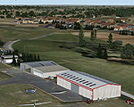
| ETAR Ramstein Airbase, Germany |
 ETAR Ramstein military airport, Germany. Plus enhanced senery for ETEK, ETIP and ETIY. Ramstein Air Base[1] is a United States Air Force (USAF) base in the German state of Rheinland-Pfalz. It serves as headquarters for the United States Air Forces in Europe (USAFE) and is also a North Atlantic Treaty Organization (NATO) installation. Ramstein is located near the town of Ramstein, in the rural district of Kaiserslautern, Germany. The scenery was designed using Airport Design Editor 9_147 and standard objects from FSX and other freeware. See PDF files for more details. By Michael Spengler 4.2 mb ETAR Ramstein military airport, Germany. Plus enhanced senery for ETEK, ETIP and ETIY. Ramstein Air Base[1] is a United States Air Force (USAF) base in the German state of Rheinland-Pfalz. It serves as headquarters for the United States Air Forces in Europe (USAFE) and is also a North Atlantic Treaty Organization (NATO) installation. Ramstein is located near the town of Ramstein, in the rural district of Kaiserslautern, Germany. The scenery was designed using Airport Design Editor 9_147 and standard objects from FSX and other freeware. See PDF files for more details. By Michael Spengler 4.2 mb |
| Author: |
O/S: all |
Version: FSX |
| Added: 30.10.11 |
Downloads: 41 |
(4.2 mb) |
| Photoreal Palms |
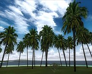 Realistic palm trees to replace the default c 1024 by 512 . 38857-palmi-na-zamen-defoltu.zip 402 kb Realistic palm trees to replace the default c 1024 by 512 . 38857-palmi-na-zamen-defoltu.zip 402 kb |
| Author: |
O/S: all |
Version: FSX |
| Added: 30.10.11 |
Downloads: 24 |
(402 kb) |
| Grass textures for FSX |
 Grass textures for FSX 4.6 mb Grass textures for FSX 4.6 mb |
| Author: |
O/S: all |
Version: FSX |
| Added: 30.10.11 |
Downloads: 11 |
(4.6 mb) |
| Amundsen-Scott Station |
| The Amundsen-Scott South Pole Station is the American scientific research station on the high plateau of Antarctica. This station is located at the southernmost place on the Earth, the Geographic South Pole, at an elevation of 2,835 meters (9301 feet) above sea level. Since the Amundsen-Scott Station is located at the South Pole, it is at the only place on the land surface of the Earth where the sun is continuously up for six months and then continuously down for six months. (The only other such place is at the North Pole, on the sea ice in the middle of the Arctic Ocean.) Thus, during each year, this station experiences one extremely long "day" and one extremely long "night". During the six-month "day", the angle of elevation of the Sun above the horizon varies continuously. The sun rises on the September equinox, reaches its maximum angle above the horizon on the summer solstice in the Southern Hemisphere, around 20 December, and sets on the March equinox. 6 kb |
| Author: |
O/S: all |
Version: FSX |
| Added: 29.10.11 |
Downloads: 7 |
(6 kb) |
| Los Angeles Airport |
 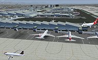 Los Angeles Airport, (CA) This Photo Real scenery is a complete rebuild for the FSX Default KLAX airport. This scenery includes my version of the New Tom Bradley International Terminal, new terminal buildings, new city buildings, and Photo Real ground textures that gives the airport a more realistic feeling. By Glenn Johnson 22 mb Los Angeles Airport, (CA) This Photo Real scenery is a complete rebuild for the FSX Default KLAX airport. This scenery includes my version of the New Tom Bradley International Terminal, new terminal buildings, new city buildings, and Photo Real ground textures that gives the airport a more realistic feeling. By Glenn Johnson 22 mb |
| Author: |
O/S: all |
Version: FSX |
| Added: 29.10.11 |
Downloads: 30 |
(22 mb) |
| FSX 44 Star Constellations |
 Modified version of FSX original stars.dat file with 44 constellations instead of the two original ones. Fly by night in north or south hemispheres and take the time to discover and learn the main and most beautiful 44 constellations during your night flights. By Jean-Marc Thiebaud. 339 kb Modified version of FSX original stars.dat file with 44 constellations instead of the two original ones. Fly by night in north or south hemispheres and take the time to discover and learn the main and most beautiful 44 constellations during your night flights. By Jean-Marc Thiebaud. 339 kb |
| Author: |
O/S: all |
Version: FSX |
| Added: 29.10.11 |
Downloads: 6 |
(339 kb) |
| Ground textures to FSX v1.5 |
 Installation: Copy the file to a folder detail1.bmp game-Scenery-World-Texture. Please, just in case, backup detail1.bmp. Ground textures V1.5, 3 options. Changes: It was possible to beat "pavement" in options 1 and 3, however, does not end at high altitudes, it becomes noticeable. Added MipMapy about which I forgot last time. In option 2, nothing has changed. 5.3 mb Installation: Copy the file to a folder detail1.bmp game-Scenery-World-Texture. Please, just in case, backup detail1.bmp. Ground textures V1.5, 3 options. Changes: It was possible to beat "pavement" in options 1 and 3, however, does not end at high altitudes, it becomes noticeable. Added MipMapy about which I forgot last time. In option 2, nothing has changed. 5.3 mb |
| Author: |
O/S: all |
Version: FSX |
| Added: 29.10.11 |
Downloads: 6 |
(5.3 mb) |
| FSX Terrain With Light And Telephone Poles |
 FSX streets and highways with light and telephone poles. By Rick McClung. 265 kb FSX streets and highways with light and telephone poles. By Rick McClung. 265 kb |
| Author: |
O/S: all |
Version: FSX |
| Added: 29.10.11 |
Downloads: 40 |
(265 kb) |
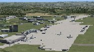
| John Wayne-Orange County Airport |
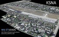 John Wayne Airport (IATA: SNA, ICAO: KSNA, FAA LID: SNA) is an airport in an unincorporated area in Orange County, California, with its mailing address in the city of Santa Ana, which is also the county seat, hence the International Air Transport Association (IATA) airport code. The main entrance to the airport is off of MacArthur Blvd in Irvine, the city that abuts the airport from the north and east. Newport Beach and Costa Mesa form the southern and western boundaries, respectively, together with a small unincorporated area along the Corona del Mar (73) Freeway. Santa Ana lies just north, not actually touching the airport directly. Originally named Orange County Airport, the county Board of Supervisors renamed it in 1979 to honor the actor John Wayne, who resided in neighboring Newport Beach and died that year. It also became the first airport to be named after an entertainer. The main runway, at 5,701 feet (1,738 m), is one of the shortest of any major airport in the United States, resulting in most passenger aircraft operating from the airport to be no larger than the Boeing 757. However, some larger cargo aircraft, such as the FedEx A310/300, fly from SNA. Some gates are built to handle planes up to the size of a Boeing 767, which can operate with payload/fuel load restrictions. No wide-body passenger aircraft are currently in scheduled service at the airport. 71 mb John Wayne Airport (IATA: SNA, ICAO: KSNA, FAA LID: SNA) is an airport in an unincorporated area in Orange County, California, with its mailing address in the city of Santa Ana, which is also the county seat, hence the International Air Transport Association (IATA) airport code. The main entrance to the airport is off of MacArthur Blvd in Irvine, the city that abuts the airport from the north and east. Newport Beach and Costa Mesa form the southern and western boundaries, respectively, together with a small unincorporated area along the Corona del Mar (73) Freeway. Santa Ana lies just north, not actually touching the airport directly. Originally named Orange County Airport, the county Board of Supervisors renamed it in 1979 to honor the actor John Wayne, who resided in neighboring Newport Beach and died that year. It also became the first airport to be named after an entertainer. The main runway, at 5,701 feet (1,738 m), is one of the shortest of any major airport in the United States, resulting in most passenger aircraft operating from the airport to be no larger than the Boeing 757. However, some larger cargo aircraft, such as the FedEx A310/300, fly from SNA. Some gates are built to handle planes up to the size of a Boeing 767, which can operate with payload/fuel load restrictions. No wide-body passenger aircraft are currently in scheduled service at the airport. 71 mb |
| Author: |
O/S: all |
Version: FSX |
| Added: 12.10.11 |
Downloads: 33 |
(71 mb) |
| | | | |
| Advertisement | |
| *Latest Site Info Panel* | |
|
| Premium Member Login | |
|
Not a Premium member yet? Click here to register.
Forgotten your password? Request a new one here.
| | | | |
| Advertisement | |
| TopSites | |
| Member Poll | |
|