| Navigation | |
| Donate | |
|
HELP KEEP OUR SERVERS ONLINE!
|
 |
Current Donation Stats |
| Dec's Goal: |
$300.00 |
| Due Date: |
Dec 31 |
| Amount in: |
$0.00 |
| Balance: |
$0.00 |
| Left to go: |
$300.00 |
| | | | |
|
fsx downloads, fsx aircraft, FS2004 aircrafts, fsx plane, Prepar3d, x-plane, fsx addons WELCOME
lbninjaas a Simnetwork new user
Registered Members: 16945 Super Administrators: 2
Moderators: 1 Users: 16938
Members Online:
Guests Online: 8
| Forum Categories | 39 |
| Forum Threads | 700 |
| Forum Posts | 1313 |
| Comments | 84 |
| News | 225 |
| Articles | 45 |
| Downloaded files | 16542 |
| Web Links | 43 |
| Total Downloaded Files | |
1686777 | | | | |
|
| Google Ads | |
| Downloads: Fsx Scenery downloads | |
|
| FSX Louisville PhotoReal Scenery |
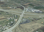 This is high resolution, 1 meter/pixel, terrain scenery for Louisville, Kentucky (KY). This section, K, features the I64 and I265 interchange in Floyd County IN. This photoscenery is for day use only and will work for any season, but shows only the USGS aerial photo data taken in April 2002. The default FSX mesh works well with this photoscenery and no additional mesh for the area needs to be purchased. This scenery was designed to work with an earlier release of FSX 3D scenery available on this site named LOUX0R.ZIP and LOUX1R.ZIP. By Jim Jones. 92 mb This is high resolution, 1 meter/pixel, terrain scenery for Louisville, Kentucky (KY). This section, K, features the I64 and I265 interchange in Floyd County IN. This photoscenery is for day use only and will work for any season, but shows only the USGS aerial photo data taken in April 2002. The default FSX mesh works well with this photoscenery and no additional mesh for the area needs to be purchased. This scenery was designed to work with an earlier release of FSX 3D scenery available on this site named LOUX0R.ZIP and LOUX1R.ZIP. By Jim Jones. 92 mb |
| Author: |
O/S: all |
Version: FSX |
| Added: 19.03.09 |
Downloads: 37 |
 (92 mb) (92 mb) |

| FSX Louisville PhotoReal Scenery |
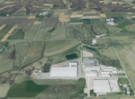 This is high resolution, 1 meter/pixel, terrain scenery for Louisville, Kentucky (KY). This section, F, features farmland in Floyd and Clark County IN. This photoscenery is for day use only and will work for any season, but shows only the USGS aerial photo data taken in April 2002. The default FSX mesh works well with this photoscenery and no additional mesh for the area needs to be purchased. This scenery was designed to work with an earlier release of FSX 3D scenery available on this site named LOUX0R.ZIP and LOUX1R.ZIP. By Jim Jones. 91 mb This is high resolution, 1 meter/pixel, terrain scenery for Louisville, Kentucky (KY). This section, F, features farmland in Floyd and Clark County IN. This photoscenery is for day use only and will work for any season, but shows only the USGS aerial photo data taken in April 2002. The default FSX mesh works well with this photoscenery and no additional mesh for the area needs to be purchased. This scenery was designed to work with an earlier release of FSX 3D scenery available on this site named LOUX0R.ZIP and LOUX1R.ZIP. By Jim Jones. 91 mb |
| Author: |
O/S: all |
Version: FSX |
| Added: 19.03.09 |
Downloads: 25 |
(91 mb) |
| FSX/SP2 Louisville Scenery Version LouX.1R |
 This is a patch file to LouX.0R, specifically designed for FSX SP2, but should also work for SP1. It fixes graphic anomalies, introduced with FSX SP2, with bridges and other objects that contained invisible textures. It also includes five C130s at KSDF KNG and a moving Belle of Louisville with smoke, steam and wake effects. This version was specifically designed to work with the previously issued 4 meter/pixel photoreal terrain scenery, LouXP01, LouXP02, LouXP03, and LouXP04 and works well with the default mesh. Subsequently, 20 additional 1 m/pixel photoreal sceneries designed for use with LouX.0R and LouX.1R have been released giving even better resolution. Their designations range from LouX1MAA to LouX1MZ. These photoreal sceneries are recommended for a better flying experience but are not mandatory. Designed by Jim Jones. 3.7 mb This is a patch file to LouX.0R, specifically designed for FSX SP2, but should also work for SP1. It fixes graphic anomalies, introduced with FSX SP2, with bridges and other objects that contained invisible textures. It also includes five C130s at KSDF KNG and a moving Belle of Louisville with smoke, steam and wake effects. This version was specifically designed to work with the previously issued 4 meter/pixel photoreal terrain scenery, LouXP01, LouXP02, LouXP03, and LouXP04 and works well with the default mesh. Subsequently, 20 additional 1 m/pixel photoreal sceneries designed for use with LouX.0R and LouX.1R have been released giving even better resolution. Their designations range from LouX1MAA to LouX1MZ. These photoreal sceneries are recommended for a better flying experience but are not mandatory. Designed by Jim Jones. 3.7 mb |
| Author: |
O/S: all |
Version: FSX/SP2 |
| Added: 14.03.09 |
Downloads: 17 |
(3.7 mb) |
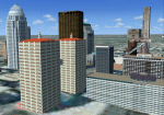
| FSX Louisville Scenery |
| This scenery includes the city of Louisville, Bowman Field and KSDF in detail and a few objects in Indiana. Most objects from previous Louisville versions are included and were completly redone in Gmax with many improvements made to them. This version was specifically designed to work with the previously issued Photoreal Terrain scenery, LouXP01, LouXP02, LouXP03, and LouXP04 and works well with the default mesh. These photoreal sceneries are recommended for a better flying experience but are not mandatory. Designed by Jim Jones. 20 mb |
| Author: |
O/S: all |
Version: FSX |
| Added: 14.03.09 |
Downloads: 18 |
(20 mb) |
| FSX K2 Detailed Mountain Scenery |
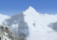 K2 is the second-highest mountain on Earth (after Mount Everest). With a peak elevation of 8,611 metres (28,251 ft), K2 is part of the Karakoram segment of the Himalayan range, and is located in the Northern Areas of Pakistan, on the border[1] between Pakistan's northern territories,[2] and the Taxkorgan Tajik Autonomous County of Xinjiang, China.[3] K2 is known as the Savage Mountain due to the difficulty of ascent and the fact that for every four people who reach the summit, one dies trying. Among the Eight-thousanders, K2 has the third highest climbing mortality rate. Karakoram is a large mountain range spanning the borders between Pakistan, China, and India, located in the regions of Gilgit, Ladakh, and Baltistan. It is one of the Greater Ranges of Asia, often considered together with the Himalaya, but not technically part of that range. By Frank Dainese 4.3 mb K2 is the second-highest mountain on Earth (after Mount Everest). With a peak elevation of 8,611 metres (28,251 ft), K2 is part of the Karakoram segment of the Himalayan range, and is located in the Northern Areas of Pakistan, on the border[1] between Pakistan's northern territories,[2] and the Taxkorgan Tajik Autonomous County of Xinjiang, China.[3] K2 is known as the Savage Mountain due to the difficulty of ascent and the fact that for every four people who reach the summit, one dies trying. Among the Eight-thousanders, K2 has the third highest climbing mortality rate. Karakoram is a large mountain range spanning the borders between Pakistan, China, and India, located in the regions of Gilgit, Ladakh, and Baltistan. It is one of the Greater Ranges of Asia, often considered together with the Himalaya, but not technically part of that range. By Frank Dainese 4.3 mb |
| Author: |
O/S: all |
Version: FSX |
| Added: 14.03.09 |
Downloads: 38 |
(4.3 mb) |
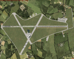
| FSX Scenery--Laurence G. Hanscom Field |
 Laurence G. Hanscom Field (KBED), Bedford, Massachusetts (MA). An improved version with adjusted aprons and taxiways, replaced default buildings, added static vehicles and more. By Jim Cook. 14 kb Laurence G. Hanscom Field (KBED), Bedford, Massachusetts (MA). An improved version with adjusted aprons and taxiways, replaced default buildings, added static vehicles and more. By Jim Cook. 14 kb |
| Author: |
O/S: all |
Version: FSX |
| Added: 14.03.09 |
Downloads: 14 |
(14 kb) |
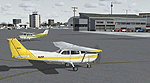
| Turweston Aerodrome |
 Turweston Aerodrome (EGBT), East Midlands, UK. Mike, one of the instructors is pictured by the cafe/flight school. By Tim Dale. 1 mb Turweston Aerodrome (EGBT), East Midlands, UK. Mike, one of the instructors is pictured by the cafe/flight school. By Tim Dale. 1 mb |
| Author: |
O/S: all |
Version: FSX |
| Added: 14.03.09 |
Downloads: 22 |
(1 mb) |
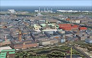
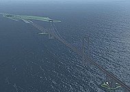
| Denmark Scenery 1.2 (Photo) file 2 of 2 |
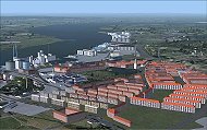  The scenery includes a number of airports, airfields and VFR landmarks throughtout the country, with special attention to the cities Copenhagen, and Aalborg. You will need to download dkscnx_12p_file1of2.zip as well. This package is designed for users of photo scenery like DanVFR or TileProxy. If you do not use photo scenery download the standard package instead. Mogens Bregnbaek, Kim Dahl, Ole Egholm, Mikael Guldager, Paul Hattens, Claus V. Holmberg, Steffen Kidal, Lars Moellebjerg, Soeren H. Nicolaisen, Frank Soerensen 98 mb The scenery includes a number of airports, airfields and VFR landmarks throughtout the country, with special attention to the cities Copenhagen, and Aalborg. You will need to download dkscnx_12p_file1of2.zip as well. This package is designed for users of photo scenery like DanVFR or TileProxy. If you do not use photo scenery download the standard package instead. Mogens Bregnbaek, Kim Dahl, Ole Egholm, Mikael Guldager, Paul Hattens, Claus V. Holmberg, Steffen Kidal, Lars Moellebjerg, Soeren H. Nicolaisen, Frank Soerensen 98 mb |
| Author: |
O/S: all |
Version: FSX |
| Added: 14.03.09 |
Downloads: 119 |
(98 mb) |
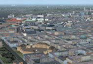
| Denmark Scenery 1.2 (Photo) file 1 of 2 |
  The scenery includes a number of airports, airfields and VFR landmarks throughtout the country, with special attention to the cities Copenhagen, and Aalborg. You will need to download dkscnx_12p_file2of2.zip as well. This package is designed for users of photo scenery like DanVFR or TileProxy. If you do not use photo scenery download the standard package instead. Mogens Bregnbaek, Kim Dahl, Ole Egholm, Mikael Guldager, Paul Hattens, Claus V. Holmberg, Steffen Kidal, Lars Moellebjerg, Soeren H. Nicolaisen, Frank Soerensen 95 mb The scenery includes a number of airports, airfields and VFR landmarks throughtout the country, with special attention to the cities Copenhagen, and Aalborg. You will need to download dkscnx_12p_file2of2.zip as well. This package is designed for users of photo scenery like DanVFR or TileProxy. If you do not use photo scenery download the standard package instead. Mogens Bregnbaek, Kim Dahl, Ole Egholm, Mikael Guldager, Paul Hattens, Claus V. Holmberg, Steffen Kidal, Lars Moellebjerg, Soeren H. Nicolaisen, Frank Soerensen 95 mb |
| Author: |
O/S: all |
Version: FSX |
| Added: 14.03.09 |
Downloads: 170 |
(95 mb) |
| Bombardier CL-415 - Static aircraft for scenery developers |
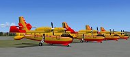 MDL and XML files of static CL-415 in Québec's livery, low polygon and texture, for scenery developers. Jean-Pierre Fillion 325 kb MDL and XML files of static CL-415 in Québec's livery, low polygon and texture, for scenery developers. Jean-Pierre Fillion 325 kb |
| Author: |
O/S: all |
Version: FSX |
| Added: 04.02.09 |
Downloads: 41 |
(325 kb) |
| Broad Peak Mountain, Karakoram Range Detailed Mountain |
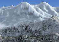 At 8,051m, Broad Peak is number 12 on the list of the fourteen 8,000m peaks, and is the third highest in the Karakoram range. It is located in Pakistan on the upper reaches of the Baltoro glacier, the main access route to the mountains which cuts through the center of the Karakoram range. Karakoram is a large mountain range spanning the borders between Pakistan, China, and India, located in the regions of Gilgit, Ladakh, and Baltistan. It is one of the Greater Ranges of Asia, often considered together with the Himalaya, but not technically part of that range. By Frank Dainese 5.1 mb At 8,051m, Broad Peak is number 12 on the list of the fourteen 8,000m peaks, and is the third highest in the Karakoram range. It is located in Pakistan on the upper reaches of the Baltoro glacier, the main access route to the mountains which cuts through the center of the Karakoram range. Karakoram is a large mountain range spanning the borders between Pakistan, China, and India, located in the regions of Gilgit, Ladakh, and Baltistan. It is one of the Greater Ranges of Asia, often considered together with the Himalaya, but not technically part of that range. By Frank Dainese 5.1 mb |
| Author: |
O/S: all |
Version: FSX |
| Added: 04.02.09 |
Downloads: 20 |
(5.1 mb) |
| FSX Scenery--Ants Aussie Airports Vol 6: NT |
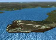  Eight photoreal strips near Darwin, Australia. PR scenery blends best with payware FTX textures. 98% of the 3D objects have been custom made. Includes Albany Park, Batchelor, Coomalie Cr, Crab Claw Is, Delissaville, Dum in Mirrie Is, Dundee Beach and Emkaytee. Goes great with Ants Aussie Airports Vol 4: Darwin (ANTSAUS4.ZIP). By Anthony Lynch 59 mb Eight photoreal strips near Darwin, Australia. PR scenery blends best with payware FTX textures. 98% of the 3D objects have been custom made. Includes Albany Park, Batchelor, Coomalie Cr, Crab Claw Is, Delissaville, Dum in Mirrie Is, Dundee Beach and Emkaytee. Goes great with Ants Aussie Airports Vol 4: Darwin (ANTSAUS4.ZIP). By Anthony Lynch 59 mb |
| Author: |
O/S: all |
Version: FSX |
| Added: 04.02.09 |
Downloads: 24 |
(59 mb) |
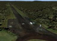
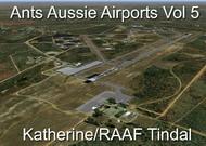
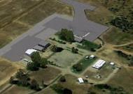
| FSX Scenery--RAAF Tindal Photoreal |
  RAAF Tindal Photoreal, Australia Ants Aussie Airports Vol 5: RAAF Tindal Tindal military base, located 300km SE of Darwin, Australia. Contains photoreal ground textures which work best if you have the payware FTX textures installed. 99% of the 3D objects have been custom made. By Anthony Lynch. 32 mb RAAF Tindal Photoreal, Australia Ants Aussie Airports Vol 5: RAAF Tindal Tindal military base, located 300km SE of Darwin, Australia. Contains photoreal ground textures which work best if you have the payware FTX textures installed. 99% of the 3D objects have been custom made. By Anthony Lynch. 32 mb |
| Author: |
O/S: all |
Version: FSX |
| Added: 04.02.09 |
Downloads: 45 |
(32 mb) |
| NAS Whiting Field |
 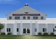 NAS Whiting Field is the busiest Naval Air Station in the Navy. Approximately 40% of all naval aviators will recieve their primary flight training at Whiting Field. Whiting Field North caters to the fixed wing contingent and Whiting Field South serves rotary wing aviators in training. The base actually serves the Navy, Air Force, Coast Guard and Marines and has water towers representing the services served. Pilots fly the T34C Turbo Mentor, T-6A Texan II (future), and for rotary wing pilots, the TH-57 Sea Ranger, which is the military version of the FSX default Bell 206 Jet Ranger. Taxiway Z connects the two airports, but since the airports are at different elevations, the taxiways were connected with a platform ramp which can be traveled with most aircraft, but cannot be used with AI. There are some acceleration objects installed. This version adds ILS on KNDZ runway 32 along with the 6 strobe MALSR. It adds radial data to the default NSE VORTAC that was DME only (112.3), and adds various support buildings and fuel trucks. There is a new control tower under construction at KNDZ. The tower has been added as well as the airport beacon on the "Fly Navy" watertower. By Jim Dhaenens. 29 mb NAS Whiting Field is the busiest Naval Air Station in the Navy. Approximately 40% of all naval aviators will recieve their primary flight training at Whiting Field. Whiting Field North caters to the fixed wing contingent and Whiting Field South serves rotary wing aviators in training. The base actually serves the Navy, Air Force, Coast Guard and Marines and has water towers representing the services served. Pilots fly the T34C Turbo Mentor, T-6A Texan II (future), and for rotary wing pilots, the TH-57 Sea Ranger, which is the military version of the FSX default Bell 206 Jet Ranger. Taxiway Z connects the two airports, but since the airports are at different elevations, the taxiways were connected with a platform ramp which can be traveled with most aircraft, but cannot be used with AI. There are some acceleration objects installed. This version adds ILS on KNDZ runway 32 along with the 6 strobe MALSR. It adds radial data to the default NSE VORTAC that was DME only (112.3), and adds various support buildings and fuel trucks. There is a new control tower under construction at KNDZ. The tower has been added as well as the airport beacon on the "Fly Navy" watertower. By Jim Dhaenens. 29 mb |
| Author: |
O/S: all |
Version: FSX |
| Added: 04.02.09 |
Downloads: 86 |
(29 mb) |
| FSX Scenery--Wallblake Airport |
 Wallblake Airport, The Valley, Anguilla (TQPF). By Jacques Botha. 6 kb Wallblake Airport, The Valley, Anguilla (TQPF). By Jacques Botha. 6 kb |
| Author: |
O/S: all |
Version: FSX |
| Added: 04.02.09 |
Downloads: 22 |
(6 kb) |
| | | | |
| Advertisement | |
| *Latest Site Info Panel* | |
|
| Premium Member Login | |
|
Not a Premium member yet? Click here to register.
Forgotten your password? Request a new one here.
| | | | |
| Advertisement | |
| TopSites | |
| Member Poll | |
|