| Navigation | |
| Donate | |
|
HELP KEEP OUR SERVERS ONLINE!
|
 |
Current Donation Stats |
| Dec's Goal: |
$300.00 |
| Due Date: |
Dec 31 |
| Amount in: |
$0.00 |
| Balance: |
$0.00 |
| Left to go: |
$300.00 |
| | | | |
|
fsx downloads, fsx aircraft, FS2004 aircrafts, fsx plane, Prepar3d, x-plane, fsx addons WELCOME
lbninjaas a Simnetwork new user
Registered Members: 16945 Super Administrators: 2
Moderators: 1 Users: 16938
Members Online:
Guests Online: 5
| Forum Categories | 39 |
| Forum Threads | 700 |
| Forum Posts | 1313 |
| Comments | 84 |
| News | 225 |
| Articles | 45 |
| Downloaded files | 16542 |
| Web Links | 43 |
| Total Downloaded Files | |
1686777 | | | | |
|
| Google Ads | |
| Downloads: Fsx Scenery downloads | |
|
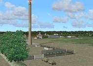
| FSX Scenery--Brodsworth Hall,Doncaster, UK |
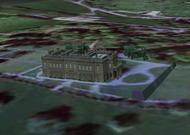 The Castles and Halls series. Optimised for FSX with Horizon VFR Photographic Scenery, Generation X, volume 3. (scenery at 2.4m/pixel terrain mesh at 5m/pixel) Should work OK with FS2004 but I haven't tried it! Built and furnished between 1861 and 1863 by Charles Thellusson. Now owned by English Heritage and open to the general public. Others in the Castles and Halls series: Chatsworth House, Belton House, Hardwick Hall, Laycock Abbey, Castle Howard, Harewood House. 956 kb The Castles and Halls series. Optimised for FSX with Horizon VFR Photographic Scenery, Generation X, volume 3. (scenery at 2.4m/pixel terrain mesh at 5m/pixel) Should work OK with FS2004 but I haven't tried it! Built and furnished between 1861 and 1863 by Charles Thellusson. Now owned by English Heritage and open to the general public. Others in the Castles and Halls series: Chatsworth House, Belton House, Hardwick Hall, Laycock Abbey, Castle Howard, Harewood House. 956 kb |
| Author: |
O/S: all |
Version: FSX |
| Added: 30.10.07 |
Downloads: 34 |
 (956 kb) (956 kb) |

| FSX Mount Tarawera New Zealand Scenery |
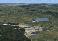 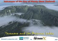 Mount Tarawera is a volcanic mountain 24 kilometres southeast of Rotorua in the North Island of New Zealand. It consists of a series of rhyolitic lava domes that were fissured down the middle by a basaltic eruption in 1886. The peaks are Ruawahia Peak, Tarawera Peak and Wahanga Peak. The summit is at 1111 metres. The crater of the volcano is a series of chasms, running for 6 kilometres northeast-southwest. The volcano is surrounded by a series of lakes, many of which were created or drastically altered in the 1886 eruption. These lakes include Lakes Tarawera, Rotomahana, Rerewhakaaitu, Okataina, Okareka, Tikitapu (Blue Lake) and Rotokakahi (Green Lake). The Tarawera River runs northeastwards across the northern flank of the mountain from Lake Tarawera. By Tim Barnes 65 mb Mount Tarawera is a volcanic mountain 24 kilometres southeast of Rotorua in the North Island of New Zealand. It consists of a series of rhyolitic lava domes that were fissured down the middle by a basaltic eruption in 1886. The peaks are Ruawahia Peak, Tarawera Peak and Wahanga Peak. The summit is at 1111 metres. The crater of the volcano is a series of chasms, running for 6 kilometres northeast-southwest. The volcano is surrounded by a series of lakes, many of which were created or drastically altered in the 1886 eruption. These lakes include Lakes Tarawera, Rotomahana, Rerewhakaaitu, Okataina, Okareka, Tikitapu (Blue Lake) and Rotokakahi (Green Lake). The Tarawera River runs northeastwards across the northern flank of the mountain from Lake Tarawera. By Tim Barnes 65 mb |
| Author: Tim Barnes |
O/S: all |
Version: FSX |
| Added: 30.10.07 |
Downloads: 112 |
(65 mb) |
| FSX Scenery--Utah Complete Update 1.1 |
 FSX Scenery--Utah Complete Update 1.1, for use with UTAHCOMP.ZIP. This update fixes minor issues with airport AFCAD files. The airports updated are: Cedar City (KCDC), Heber City (36U), Hill AFB (KHIF), Logan (KLGU), Moab (KCNY), Morgan (42U), Ogden (KOGD), Provo (KPVU), Salt Lake City Int'l (KSLC), Salt Lake City #2 (U42), St. George (KSGU), Tooele (KTVY), and Vernal (KVEL). The ATIS at KPVU should also work now. Utah Complete 1.0 is required before installing this update. By James Udall. 107 kb FSX Scenery--Utah Complete Update 1.1, for use with UTAHCOMP.ZIP. This update fixes minor issues with airport AFCAD files. The airports updated are: Cedar City (KCDC), Heber City (36U), Hill AFB (KHIF), Logan (KLGU), Moab (KCNY), Morgan (42U), Ogden (KOGD), Provo (KPVU), Salt Lake City Int'l (KSLC), Salt Lake City #2 (U42), St. George (KSGU), Tooele (KTVY), and Vernal (KVEL). The ATIS at KPVU should also work now. Utah Complete 1.0 is required before installing this update. By James Udall. 107 kb |
| Author: James Udall |
O/S: all |
Version: FSX |
| Added: 25.10.07 |
Downloads: 117 |
(107 kb) |
| FSX Scenery--Utah Complete |
 FSX Scenery--Utah Complete v1.0, including Salt Lake City International Airport (KSLC), UT. The scenery covers most of the state and upgrades the landscape, scenery objects, airports, etc. Other airports featured include: Provo (KPVU), Ogden (KOGD), St. George (KSGU), Logan-Cache (KLGU), Heber Valley (36U), Cedar City (KCDC), Moab (KCNY), Vernal (KVEL), and more. By James Udall. 4.4 mb FSX Scenery--Utah Complete v1.0, including Salt Lake City International Airport (KSLC), UT. The scenery covers most of the state and upgrades the landscape, scenery objects, airports, etc. Other airports featured include: Provo (KPVU), Ogden (KOGD), St. George (KSGU), Logan-Cache (KLGU), Heber Valley (36U), Cedar City (KCDC), Moab (KCNY), Vernal (KVEL), and more. By James Udall. 4.4 mb |
| Author: James Udall |
O/S: all |
Version: FSX |
| Added: 25.10.07 |
Downloads: 108 |
(4.4 mb) |
| FSX Kansas City Downtown Scenery |
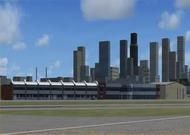  Unzip the contents of this zip file to your FSX directory with "Use folder names" checked. This scenery is a completely new and latest rendition of Kansas City Downtown Airport and was designed with FSX in mind. Because of exclude differences it does not work as I have created it in FS2004. Sorry! This project was created using GMAX, ScenGenX, Instant Scenery and AFCAD2. The airport runway and taxiway layout use the layout from FS2004 so do not have runway and taxiway signage that comes with FSX. 3.1 mb Unzip the contents of this zip file to your FSX directory with "Use folder names" checked. This scenery is a completely new and latest rendition of Kansas City Downtown Airport and was designed with FSX in mind. Because of exclude differences it does not work as I have created it in FS2004. Sorry! This project was created using GMAX, ScenGenX, Instant Scenery and AFCAD2. The airport runway and taxiway layout use the layout from FS2004 so do not have runway and taxiway signage that comes with FSX. 3.1 mb |
| Author: |
O/S: all |
Version: FSX |
| Added: 25.10.07 |
Downloads: 53 |
(3.1 mb) |
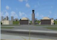
| FSX military airfield Kamenz (FutK-612) |
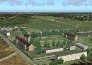  The military airfield Kamenz (EDCM) was one part of the Officer Candidates School of the airforce/airdefence of the former NVA (national peoples army). Here were instruct future pilots and navigators of cargo planes and also pilots for the civilian east german airline "Interflug". Officers for radar units and military air traffic controllers were also instruct in this military institution. Autoren: Volker Löw, Rolf-Uwe Hochmuth 5 mb The military airfield Kamenz (EDCM) was one part of the Officer Candidates School of the airforce/airdefence of the former NVA (national peoples army). Here were instruct future pilots and navigators of cargo planes and also pilots for the civilian east german airline "Interflug". Officers for radar units and military air traffic controllers were also instruct in this military institution. Autoren: Volker Löw, Rolf-Uwe Hochmuth 5 mb |
| Author: Volker Löw, Rolf-Uwe Hochmuth |
O/S: all |
Version: FSX |
| Added: 25.10.07 |
Downloads: 43 |
(5 mb) |
| FSX Scenery--Ado-Shem |
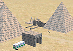 FSX Scenery--Ado-Shem. Egyptologists have discovered a previously unknown set of ruins in the south-western corner of Egypt, which they have named Ado-Shem. Not only are they excited by this discovery, they feel the ruins could lead them to the long lost Giant Pyramid of Ancient Egypt. But they haven't quite managed to crack the code yet. Can you decipher the hieroglphs to find the Giant Pyramid? By Andy Johnston. 1 mb FSX Scenery--Ado-Shem. Egyptologists have discovered a previously unknown set of ruins in the south-western corner of Egypt, which they have named Ado-Shem. Not only are they excited by this discovery, they feel the ruins could lead them to the long lost Giant Pyramid of Ancient Egypt. But they haven't quite managed to crack the code yet. Can you decipher the hieroglphs to find the Giant Pyramid? By Andy Johnston. 1 mb |
| Author: Andy Johnston |
O/S: all |
Version: FSX |
| Added: 25.10.07 |
Downloads: 25 |
(1 mb) |
| FSX Scenery--19 M Balearic Terrain Mesh |
 FSX Scenery--19 M Balearic Terrain Mesh. Specifically designed for FSX, this is a highly detailed mesh at 19m resolution for the Balearic Islands (Baleares). It offers a far higher levels of details than SRTM terrain mesh. By Raimondo Taburet. 2 mb FSX Scenery--19 M Balearic Terrain Mesh. Specifically designed for FSX, this is a highly detailed mesh at 19m resolution for the Balearic Islands (Baleares). It offers a far higher levels of details than SRTM terrain mesh. By Raimondo Taburet. 2 mb |
| Author: Raimondo Taburet |
O/S: all |
Version: FSX |
| Added: 25.10.07 |
Downloads: 62 |
(2 mb) |
| FSX Scenery--Patos de Minas Airport |
 FSX Scenery--Patos de Minas Airport (SNPD), Brazil, v1.0. By Saulo Ferreira Leite. Adapted to FSX by Cesar Marinho. 2.4 mb FSX Scenery--Patos de Minas Airport (SNPD), Brazil, v1.0. By Saulo Ferreira Leite. Adapted to FSX by Cesar Marinho. 2.4 mb |
| Author: Cesar Marinho |
O/S: all |
Version: FSX |
| Added: 25.10.07 |
Downloads: 25 |
(2.4 mb) |
| FSX Scenery--Santarem Airport |
 FSX Scenery--Santarem Airport (SBSN), Brazil, v1.0; functional, with taxiway signs. By Gustavo Luna. 1.5 mb FSX Scenery--Santarem Airport (SBSN), Brazil, v1.0; functional, with taxiway signs. By Gustavo Luna. 1.5 mb |
| Author: Gustavo Luna |
O/S: all |
Version: FSX |
| Added: 25.10.07 |
Downloads: 28 |
(1.5 mb) |
| FSX Scenery--Recife Airport |
 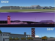 FSX Scenery--Recife Airport (SBRF), Brazil, v3.1; functional, with taxiways signs. By Gustavo Luna. 6.1 mb FSX Scenery--Recife Airport (SBRF), Brazil, v3.1; functional, with taxiways signs. By Gustavo Luna. 6.1 mb |
| Author: Gustavo Luna |
O/S: all |
Version: FSX |
| Added: 20.10.07 |
Downloads: 120 |
(6.1 mb) |
| FSX Scenery Of RAF Coningsby |
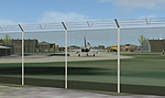 FSX Scenery Of RAF Coningsby, UK. A detailed representation of the home of the Eurofighter Typhoon in operational service in the UK. Gmax scenery with photo-tiles. Features aircraft shelters with animated doors, flight line equipment and personnel and options to maintain frame rate for users with lower end PCs. By John Young, UKMIL. 9.9 mb FSX Scenery Of RAF Coningsby, UK. A detailed representation of the home of the Eurofighter Typhoon in operational service in the UK. Gmax scenery with photo-tiles. Features aircraft shelters with animated doors, flight line equipment and personnel and options to maintain frame rate for users with lower end PCs. By John Young, UKMIL. 9.9 mb |
| Author: John Young |
O/S: all |
Version: FSX |
| Added: 20.10.07 |
Downloads: 69 |
(9.9 mb) |
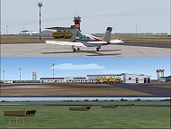
| FSX Scenery - Yuba County Airport |
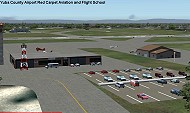 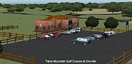 is a public airport located three miles (4.8 km) southeast of Marysville, serving Yuba County, California, USA. The airport has two runways and is mostly used for general aviation. Oroville Municipal Airport (IATA: OVE, ICAO: KOVE) is a public airport located 3 miles (5 km) southwest of the city of Oroville in Butte County, California, USA. Oroville Municipal Airport covers 920 acres and has two runways. This airport is about 23nm NW of Yuba Co. An 18 hole golf course is located right next to the facility for you "Fly-in Golfers". EZ Scenry libraries require, some are included. By John B. Loney, Jr. and Robert Lacy. 10 mb is a public airport located three miles (4.8 km) southeast of Marysville, serving Yuba County, California, USA. The airport has two runways and is mostly used for general aviation. Oroville Municipal Airport (IATA: OVE, ICAO: KOVE) is a public airport located 3 miles (5 km) southwest of the city of Oroville in Butte County, California, USA. Oroville Municipal Airport covers 920 acres and has two runways. This airport is about 23nm NW of Yuba Co. An 18 hole golf course is located right next to the facility for you "Fly-in Golfers". EZ Scenry libraries require, some are included. By John B. Loney, Jr. and Robert Lacy. 10 mb |
| Author: John B. Loney, Jr. and Robert Lacy |
O/S: all |
Version: FSX |
| Added: 20.10.07 |
Downloads: 26 |
(10 mb) |
| Valley Flying Field - WAVF (for FSX) |
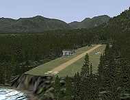 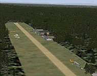 This is a remake of Valley Flying Field by Bill and Phil specifically for FSX. Designed for use with Ultimate Terrain X (UTX), the FSX Mesh Resolution set to 10m, the Mesh Resolution set to 80, and some older (FS9) object libraries (see list below). Other settings or without UTX installed, may cause unpredictable results... like the airport sitting on a plateau or the nearby lake missing. by Phil "Snowman" Cayton & Bill "Willybee" Dick, 345 kb This is a remake of Valley Flying Field by Bill and Phil specifically for FSX. Designed for use with Ultimate Terrain X (UTX), the FSX Mesh Resolution set to 10m, the Mesh Resolution set to 80, and some older (FS9) object libraries (see list below). Other settings or without UTX installed, may cause unpredictable results... like the airport sitting on a plateau or the nearby lake missing. by Phil "Snowman" Cayton & Bill "Willybee" Dick, 345 kb |
| Author: Phil "Snowman" Cayton & Bill "Willy |
O/S: all |
Version: FSX |
| Added: 20.10.07 |
Downloads: 30 |
(345 kb) |
| FSX Scenery--Sao Luis Airport |
 FSX Scenery--Sao Luis Airport (SBSL), Brazil. Functional, with taxiway signs. By Gustavo Luna. 1 mb FSX Scenery--Sao Luis Airport (SBSL), Brazil. Functional, with taxiway signs. By Gustavo Luna. 1 mb |
| Author: Gustavo Luna |
O/S: all |
Version: FSX |
| Added: 20.10.07 |
Downloads: 32 |
(1 mb) |
| | | | |
| Advertisement | |
| *Latest Site Info Panel* | |
|
| Premium Member Login | |
|
Not a Premium member yet? Click here to register.
Forgotten your password? Request a new one here.
| | | | |
| Advertisement | |
| TopSites | |
| Member Poll | |
|